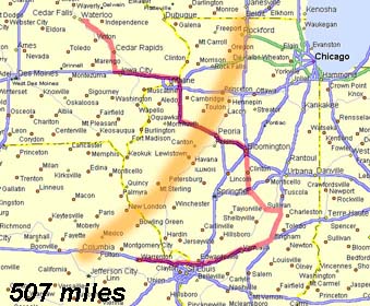
- Our path for the whole chase day is shown here in red. The approximate starting location
of the squall line is shown in orange. This line tracked quickly SE through Illinois.
- Click to enlarge.
|
THE MAKING OF THE CHASE: Chasing the day before had left us in Waterloo,
Iowa. There was a moderate risk for central Illinois. It looked like a big squall line
setup for the day, but the discussion mentioned some hope of cells remaining isolated and
possibly supercellular at least at the start, so we decided to give it a go anyway.
Left at about 10 am south on 380 and into Illinois. We stopped for data at around 2 pm
in far NW Illinois. Saw that storms were already firing along the cold front....great. We
were a good 60 or 70 miles north of the front with it moving away to the SE. There was a
lot of deep layer shear in the area, so we decided to try it anyway.
The first tornado warning went up for central Illinois at about 5:30 pm as we were
entering the Peoria area. The sky was a solid wall of grey, so we couldn't make out any
individual storms. We decided to continue south anyway.
Soon, more tornado warnings were issued for storms both north and south of us on the
line. We still couldn't see anything.
|
| SUMMARY: Well, I wish it could have been a better day. We
thought this would turn into a squall line, but didn't expect it to do it so quickly. It
was a marginal day, but we're out to chase, so that's what we did! Sure was better than
staying home! |
